![](/images/other/stat-length.png)
![Excursión Senderismo Le Poët-Sigillat - col d'Ambonne ( Poët-Sigillat) - Photo](https://media.geolcdn.com/t/1900/400/ext.pjpeg?maxdim=2&url=https%3A%2F%2Fstatic1.geolcdn.com%2Fsiteimages%2Fupload%2Ffiles%2F1553511878bg_sport_marche.png)
col d'Ambonne ( Poët-Sigillat)
YVESBRULARD
Usuario
![Longitud](/images/other/stat-length.png)
Longitud
5,9 km
![Altitud máxima](https://static1.geolcdn.com/siteimages/upload/files/1508320355ic_sort_altitude_max_24dp.png)
Altitud máxima
1246 m
![Desnivel positivo](https://static1.geolcdn.com/siteimages/upload/files/1508320355ic_sort_den_pos_24dp.png)
Desnivel positivo
476 m
![Km-Effort](/images/other/stat-length.png)
Km-Effort
12,2 km
![Altitud mínima](https://static1.geolcdn.com/siteimages/upload/files/1508320355ic_sort_altitude_min_24dp.png)
Altitud mínima
773 m
![Desnivel negativo](https://static1.geolcdn.com/siteimages/upload/files/1508320355ic_sort_den_neg_24dp.png)
Desnivel negativo
478 m
![Boucle](https://static1.geolcdn.com/siteimages/upload/files/16400158638029165_repeat_loop_refresh_sync_direction_icon.png)
Boucle
Sí
Fecha de creación :
2017-07-29 00:00:00.0
Última modificación :
2017-07-29 00:00:00.0
![Senderismo](https://static1.geolcdn.com/sitytour/trail-icons/101.png)
3h00
Dificultad : Muy fácil
![Escanee este código QR para abrir la excursión en la aplicación SityTrail](https://capi.geolives.com/qq0zvz2zws4bq2lad0pu/sitytour/trails/798301/qr.png?size=200)
Aplicación GPS de excursión GRATIS
A propósito
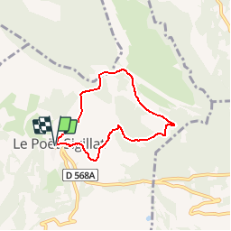
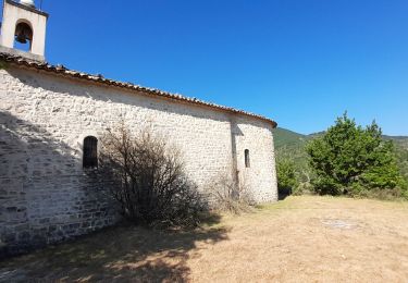
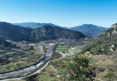
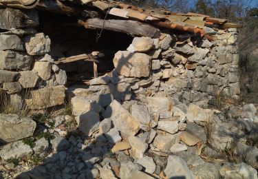
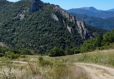
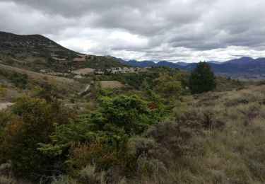
Ruta Senderismo de 5,9 km a descubrir en Auvergne-Rhône-Alpes, Drôme, Le Poët-Sigillat. Esta ruta ha sido propuesta por YVESBRULARD.
Descripción
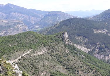
cette randonnée sur les pentes ensoleillées au dessus de Pöet-Sigillat permettent de mieux voir et comprendre les Baronnies, de la vallée de L'Ennuye au mont Ventoux
Localización
País:
France
Región :
Auvergne-Rhône-Alpes
Departamento/provincia :
Drôme
Municipio :
Le Poët-Sigillat
Localidad:
Unknown
Salida:(Dec)
Salida:(UTM)
684572 ; 4915479 (31T) N.
Comentarios
Excursiones cerca
![Excursión Senderismo Sahune - rocher de Bramard - Photo](https://media.geolcdn.com/t/375/260/ext.jpg?maxdim=2&url=https%3A%2F%2Fmedia.geolcdn.com%2Ff%2Fb6e96133-4660-4d7a-bbea-eb48a170bb19.jpg)
![Senderismo Senderismo](https://static1.geolcdn.com/sitytour/trail-icons/101.png)
rocher de Bramard
Senderismo
Medio
Sahune,
Auvergne-Rhône-Alpes,
Drôme,
France
![](/images/other/stat-length.png)
12,4 km | 21 km-effort
4h 35min
![](https://static1.geolcdn.com/siteimages/upload/files/16400158638029165_repeat_loop_refresh_sync_direction_icon.png)
Sí
![Excursión Senderismo Rémuzat - rocher du caire - Photo](https://media.geolcdn.com/t/375/260/ext.jpg?maxdim=2&url=https%3A%2F%2Fmedia.geolcdn.com%2Ff%2F60db15ec-1b2a-4873-b1d2-ea69db9a6899.jpg)
![Senderismo Senderismo](https://static1.geolcdn.com/sitytour/trail-icons/101.png)
rocher du caire
Senderismo
Difícil
Rémuzat,
Auvergne-Rhône-Alpes,
Drôme,
France
![](/images/other/stat-length.png)
10,9 km | 20 km-effort
3h 48min
![](https://static1.geolcdn.com/siteimages/upload/files/16400158638029165_repeat_loop_refresh_sync_direction_icon.png)
Sí
![Excursión Bici de carretera Sainte-Jalle - Col d’Ey depuis Sainte Jalle via Rochebrune - Photo](https://media.geolcdn.com/t/375/260/ext.jpg?maxdim=2&url=https%3A%2F%2Fmedia.geolcdn.com%2Ff%2F2d32934e-f0a5-4ec9-8fdb-ba37b4d45c7a.jpg)
![Bici de carretera Bici de carretera](https://static1.geolcdn.com/sitytour/trail-icons/201.png)
Col d’Ey depuis Sainte Jalle via Rochebrune
Bici de carretera
Medio
Sainte-Jalle,
Auvergne-Rhône-Alpes,
Drôme,
France
![](/images/other/stat-length.png)
18,8 km | 24 km-effort
1h 55min
![](https://static1.geolcdn.com/siteimages/upload/files/16400158638029165_repeat_loop_refresh_sync_direction_icon.png)
Sí
![Excursión Senderismo Arpavon - BruBer-Arpavon : ND Consolation - Photo](https://media.geolcdn.com/t/375/260/ext.jpg?maxdim=2&url=https%3A%2F%2Fmedia.geolcdn.com%2Ff%2Fac6ca5aa-60a5-46e8-a1a6-5885958bb4b9.jpg)
![Senderismo Senderismo](https://static1.geolcdn.com/sitytour/trail-icons/101.png)
BruBer-Arpavon : ND Consolation
Senderismo
Medio
Arpavon,
Auvergne-Rhône-Alpes,
Drôme,
France
![](/images/other/stat-length.png)
5,5 km | 8,2 km-effort
1h 30min
![](https://static1.geolcdn.com/siteimages/upload/files/16400158638029165_repeat_loop_refresh_sync_direction_icon.png)
Sí
![Excursión Senderismo Sahune - Asptt SAHUNE VILLEPERDRIX - Photo](https://media.geolcdn.com/t/375/260/ext.jpg?maxdim=2&url=https%3A%2F%2Fmedia.geolcdn.com%2Ff%2F1db90b63-99dd-46d4-8a4a-760727bd6a27.jpg)
![Senderismo Senderismo](https://static1.geolcdn.com/sitytour/trail-icons/101.png)
Asptt SAHUNE VILLEPERDRIX
Senderismo
Difícil
Sahune,
Auvergne-Rhône-Alpes,
Drôme,
France
![](/images/other/stat-length.png)
16,5 km | 27 km-effort
6h 29min
![](https://static1.geolcdn.com/siteimages/upload/files/16400158638029165_repeat_loop_refresh_sync_direction_icon.png)
Sí
![Excursión Senderismo Sahune - 26 sahune - Photo](https://media.geolcdn.com/t/375/260/ext.jpg?maxdim=2&url=https%3A%2F%2Fmedia.geolcdn.com%2Ff%2Fa180cf7c-fb96-48c2-9d7c-76f8ea234985.jpg)
![Senderismo Senderismo](https://static1.geolcdn.com/sitytour/trail-icons/101.png)
26 sahune
Senderismo
Medio
Sahune,
Auvergne-Rhône-Alpes,
Drôme,
France
![](/images/other/stat-length.png)
19,5 km | 33 km-effort
7h 20min
![](https://static1.geolcdn.com/siteimages/upload/files/16400158638029165_repeat_loop_refresh_sync_direction_icon.png)
No
![Excursión Senderismo Rémuzat - les Aiguilles en partant de Remuzat - Photo](https://media.geolcdn.com/t/375/260/ext.jpg?maxdim=2&url=https%3A%2F%2Fmedia.geolcdn.com%2Ff%2F8caa209c-8d1c-426d-8ea8-486025dba5cb.jpg)
![Senderismo Senderismo](https://static1.geolcdn.com/sitytour/trail-icons/101.png)
les Aiguilles en partant de Remuzat
Senderismo
Medio
Rémuzat,
Auvergne-Rhône-Alpes,
Drôme,
France
![](/images/other/stat-length.png)
16 km | 29 km-effort
4h 45min
![](https://static1.geolcdn.com/siteimages/upload/files/16400158638029165_repeat_loop_refresh_sync_direction_icon.png)
Sí
![Excursión Senderismo Le Poët-Sigillat - poët Sigillat-col de Soubeyrand-Tarendol - Photo](https://media.geolcdn.com/t/375/260/ext.jpg?maxdim=2&url=https%3A%2F%2Fmedia.geolcdn.com%2Ff%2F62191b6d-cd1d-491d-b6a6-a8d2adebac5d.jpg)
![Senderismo Senderismo](https://static1.geolcdn.com/sitytour/trail-icons/101.png)
poët Sigillat-col de Soubeyrand-Tarendol
Senderismo
Medio
Le Poët-Sigillat,
Auvergne-Rhône-Alpes,
Drôme,
France
![](/images/other/stat-length.png)
12,9 km | 20 km-effort
3h 35min
![](https://static1.geolcdn.com/siteimages/upload/files/16400158638029165_repeat_loop_refresh_sync_direction_icon.png)
Sí
![Excursión Senderismo Sainte-Jalle - GRP Baronnies Ste Jalle Arpavon 18km - Photo](https://media.geolcdn.com/t/375/260/ext.jpg?maxdim=2&url=https%3A%2F%2Fmedia.geolcdn.com%2Ff%2F8bd5c524-a80b-4e1f-b0f8-b1a379789e0d.jpg)
![Senderismo Senderismo](https://static1.geolcdn.com/sitytour/trail-icons/101.png)
GRP Baronnies Ste Jalle Arpavon 18km
Senderismo
Medio
Sainte-Jalle,
Auvergne-Rhône-Alpes,
Drôme,
France
![](/images/other/stat-length.png)
18 km | 27 km-effort
5h 32min
![](https://static1.geolcdn.com/siteimages/upload/files/16400158638029165_repeat_loop_refresh_sync_direction_icon.png)
Sí